Field checked 2026-05-30
Tomari Port (Tomarin) Complete Guide
Find boarding points, tickets, transport and nearby stays.
What do you need?
Ticket counters and boarding points are separate. On your travel date, follow the displayed vessel name and boarding-point number.
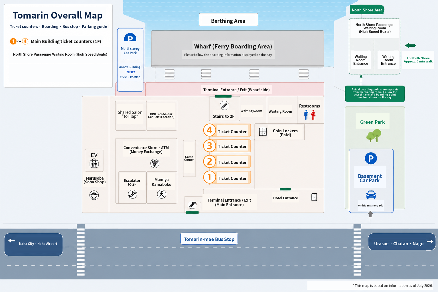
Tomarin Overall Map
This map shows the relative locations of the ticket counters, the ferry boarding area in front of the main building on the south-shore side, the North Shore Passenger Waiting Room, the bus stop, the multi-storey car park, and the basement car park.
Getting to Tomarin
Parking
The multi-storey and basement car parks are separate. Compare fees, payment methods, capacity and height limits.
Bus stops
At Tomari Takahashi, the side of the road depends on your destination. Check your service before boarding.
Taxi stand
The walking route from the main building’s first-floor ferry-side exit to the taxi stand.
For northern Okinawa and Churaumi, use the Tomarin / Tomari Port side. For central Naha and the airport, use the mic21 side across Route 58. For Chatan, check your specific service.
Bags and time before departure
Before departure
Check how much time you have, allowing for boarding procedures and the walk to your boarding point.
Coin lockers
Separate lockers on the main building’s first floor and inside the Queen Zamami waiting room on the north shore.
Lawson & Heart Corporation
On the main building’s first floor: a convenience store and a shop for clothing and marine supplies.
Food & cafes
Ryutan on the first floor; VINILE PARADISO CAFE and Oasis8 Cafe on the second.
Second-floor harbor deck
Benches, port views, restrooms and coin laundry facilities.
Walk to Tomari Iyumachi
A separate building, about 10–15 minutes on foot each way. Allow time for the return walk, your visit, boarding procedures and reaching your boat.
Places to visit from Tomarin
Kokusai Street
Walk from the main building to the Prefectural Office end of Kokusai Street, or check the approximate taxi time.
Chatan
Compare local buses and the Chatan Liner, including stops for American Village and Depot Island.
Churaumi Aquarium
The Yanbaru Express airport-line route and drop-off stop, departing from Tomari Takahashi on the port side.